Human Development Index 2012

The Human Development Index (HDI) is a composite measure that includes three indicators: life expectancy at birth, level of education attained, and income. The HDI is an alternative to the purely economical GDP, that quantifies economic growth only. Thus, the HDI provide a way to gauge the development of a country. The HDI for 2012 includes 187 countries.

The HDI ranks countries according to their degree of development using a scale from 0 to1, 0 being the least developed and 1 being the most developed country.

In the HDI map above, published by the Brazilian media site Globo.com we find that Norway has a score of 0.955, ranking number one as the most developed country (color green). Norway is followed by Australia, the U.S., the Netherlands, Germany, New Zealand, among others.

At the other end of the spectrum we find the least developed nations (color purple), including the majority of African nations, Pakistan, Afghanistan, Myanmar, Bangladesh, Nepal, and Papua New Guinea.


Industrial Water Consumption by Country

Across the globe, freshwater is consumed by four different economic sectors: domestic, industry, energy and agriculture. The agricultural sector is the largest consumer of water. The industrial and energy sectors follow suit, using 20% of available water resources.

This map (above), published by the Sustainable Sanitation and Water Management Toolbox, shows how much water is used by the industrial sector by each country. For the year 2009, the largest consumers of water for industrial use were the U.S. and Europe. Water consumption by the industrial sector accounted for 50% of total water use.


Billionaires and their Wealth by Country

This map of the world’s wealthiest citizens was created by Forbes. A total of 1,426 billionaires were found across the globe, worth $5.4 trillion combined.

The wealth of billionaires in the U.S. alone, 1,872.5 trillion, is larger than the combined wealth of billionaires in each continent. The wealth of the world’s richest in the Americas is an outstanding $2.4 trillion thanks to the contributions of billionaires mainly from the U.S., Brazil, Mexico, Canada, Chile, Colombia, Peru, and Venezuela.

The Americas are followed by Europe, where the wealth of its billionaires combined is valued at $1.55 trillion. Europe is followed by Asia with the wealth of its billionaires estimated at $1.16 trillion. Africa and the Middle East come at last, where the total net worth of its richest citizens is valued at $279 billion.


Number of Deaths in World War II

This visualization found in Wikimedia.org, shows World War II casualties per country by number and percentage of population, as well as the percentage of military and civilian deaths for the Allied and the Axis Powers.

The countries with the largest number of casualties were the Soviet Union, China, Germany, Poland, and Indonesia. As a percentage of the population, the nations with the  largest number of casualties were Lithuania, Poland, Latvia, Germany, and the Soviet Union.

For the Allied forces, the heaviest casualties were inflicted on the civilian population, whereas the largest number of casualties for the Axis forces were inflicted on the military.


Map of Internet Activity

click here to see the animation

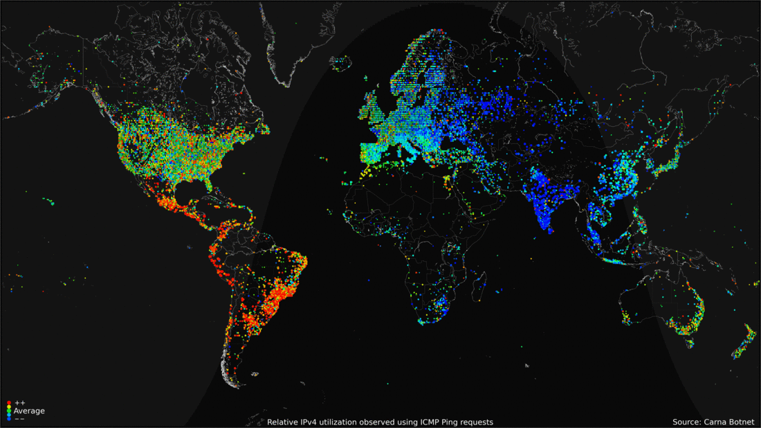
Someone hacked thousands of computers all around the world in order to create a map of internet activity in the course of a day.

In this map from FastCo.Design, the red dots show peak internet activity around the world at different times of the day, while the blue dots show base traffic. Some interesting conclusions point to the fact that nighttime affects the U.S. and Europe very little, due to the fact that permanent internet connectivity is available.

The World as 100 People

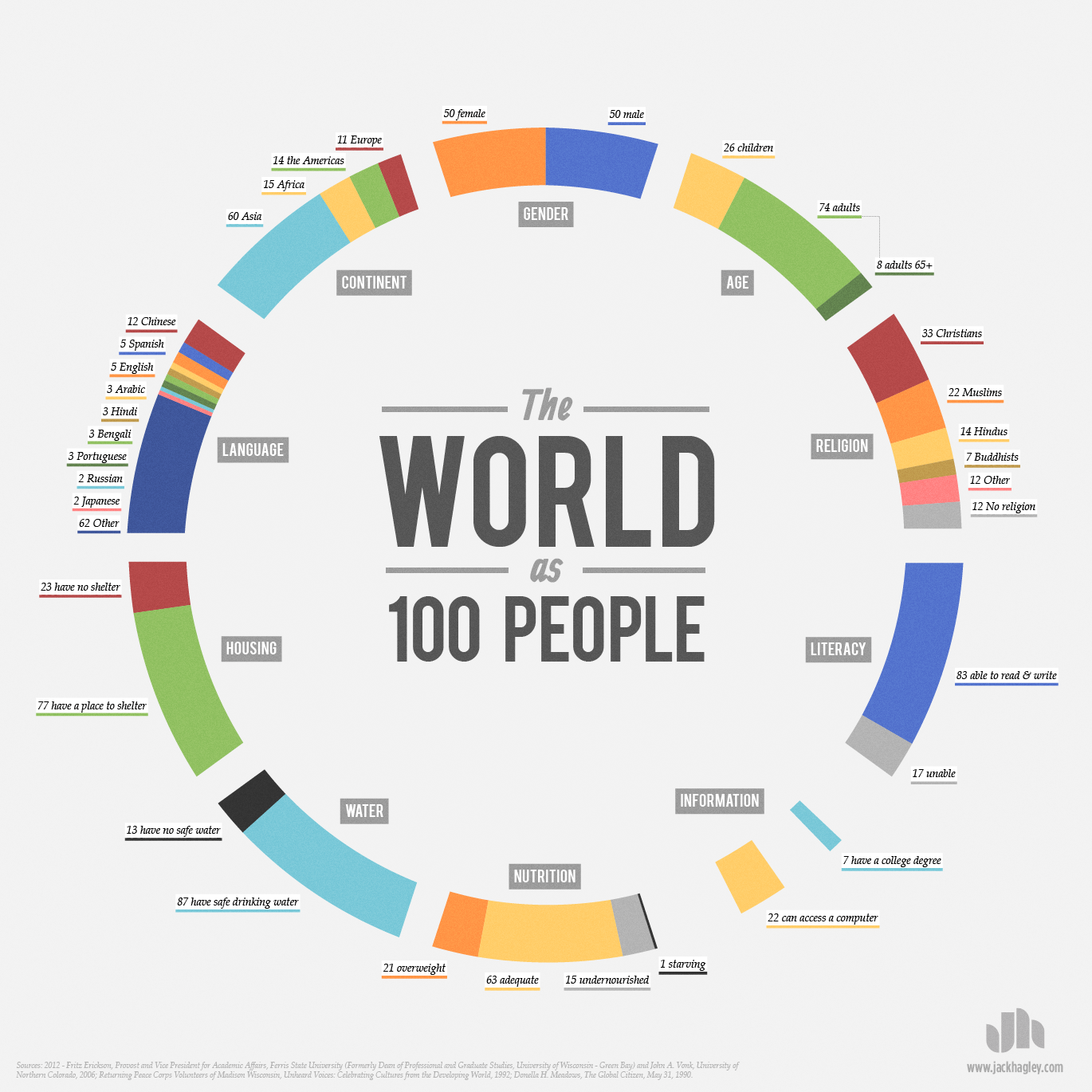
In this interesting infographic, created by Jack Hagley, we take a look at the world as if the total population of the world was 100 people. The information presented covers topics such as the distribution of gender, information, spoken languages, literacy, religion, age, housing, water, nutrition, and population inhabiting each continent.


Major Causes of Death in the 20th Century

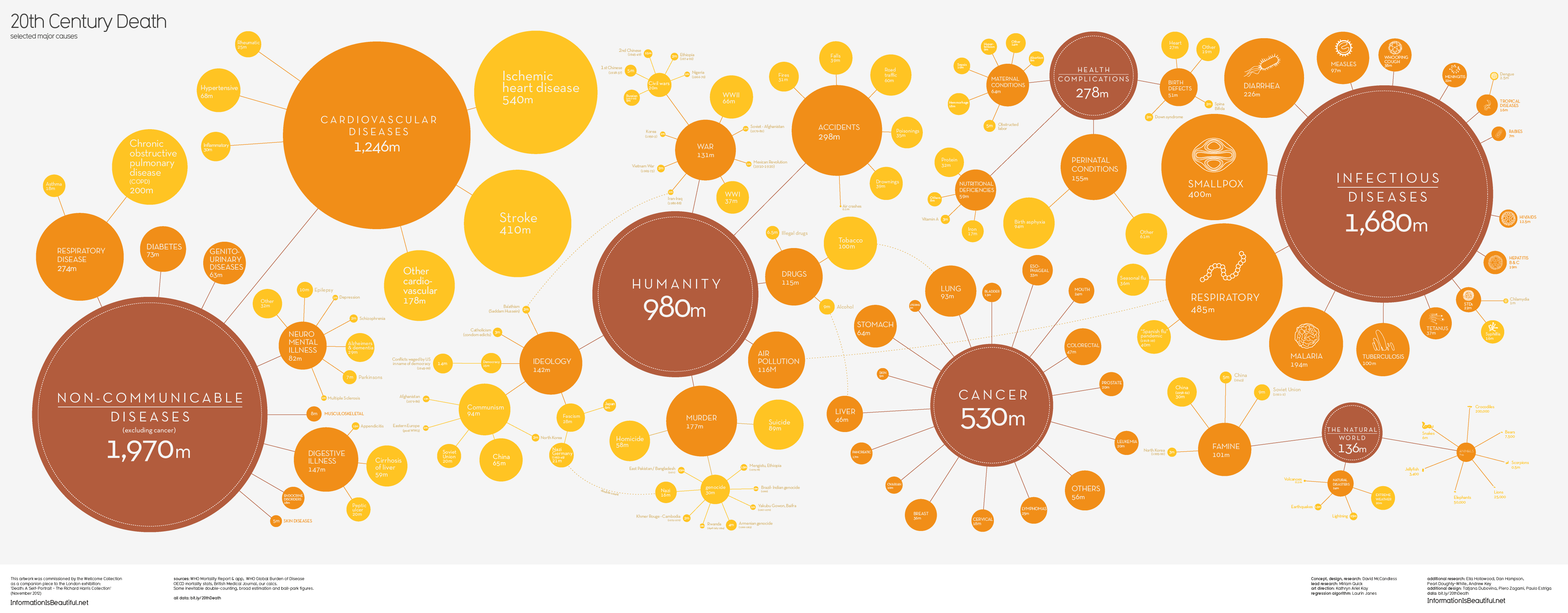
This visualization by Information is Beautiful shows the major causes of death for the 20th century.

According to the data in this graphic, the most common causes of death were non-communicable diseases (excluding cancer) such as cardiovascular diseases, diabetes, respiratory diseases, neuro-mental illness, and digestive illness; infectious diseases such as smallpox, diarrhea, malaria, tuberculosis, and respiratory diseases; death caused by humans such as murder, war, suicides, air pollution, drugs, and accidents; health complications, and cancer.


Drone Attacks Visualized

click to enlarge

The use of drones to eliminate enemy targets has become routine practice for U.S. military operations since 2004, specially in Afghanistan and Pakistan.

Pitch Interactive has created the visualization above, showing the number of drone attacks since 2004 to date, as well as the number of casualties. Of an estimated 3,105 casualties, 175 were children (5.6%), 535 were civilians (17.2%), and 2,348 (75.6%) were casualties classified as other, which can include male able-bodied enemy combatants, their neighbors, and possible militants.

Data for this visualization was obtained by Pitch Interactive from the Bureau of Investigative Journalism,  the New America Foundation, and Living Under Drones.


Government Debt as a Percentage of GDP

Government Debt as a Percentage of GDP

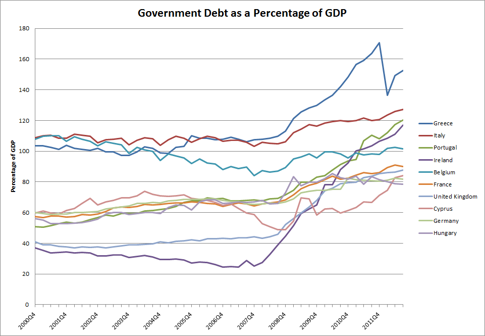
Using data from Eurostat, we identified the top 10 European countries with the highest government debt as a percentage of GDP. The chart above shows that as of the third quarter of 2012, the latest period for which quarterly data is available, Greece, Italy, and Portugal had the highest government debt ratio. Ireland was close behind Portugal, with a ratio that has been increasing at the fastest rate out of all the countries in the list. Cyprus, which has been in the news lately due to problems in its banking sector, had a debt ratio not much higher than Germany.

Source: Eurostat

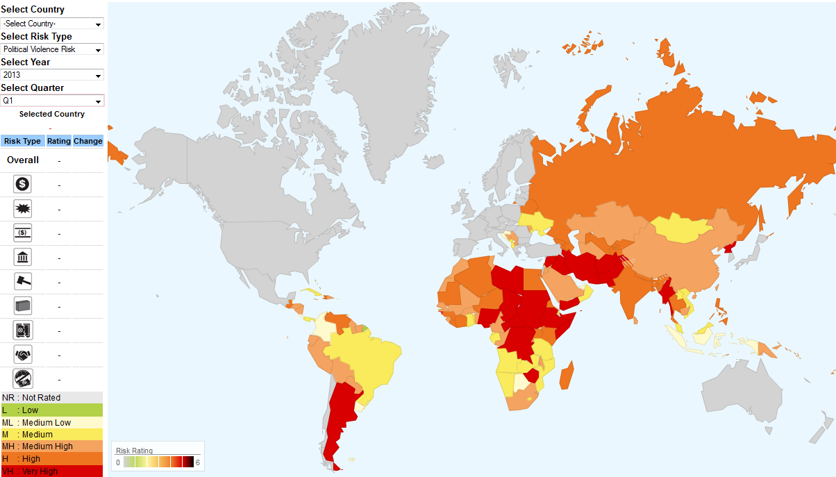
Political Violence Risk by Country

This map created by Aon Risk Solutions, as part of its Crisis Management Web Analytics tool, shows which countries are at risk of facing political violence.

Political violence risks include terrorism, strikes, riots, civil upheaval, sabotage, war, civil war, rebellion, revolution, insurrection, a hostile act by a belligerent power, mutiny or a coup d’etat.

Based on a rating from 0 to 6, 0 being low risk (green), and 6 being very high risk (red), we can see that the countries that carry the highest risk of political violence include Argentina in the Americas; Chad, Nigeria, Sudan, Ethiopia, Somalia, Central African Republic, Democratic Republic of Congo, and Zimbabwe in Africa; Yemen, Iran, Iraq, Afghanistan, Pakistan, Syria, Myanmar, and North Korea in Asia. OECD countries are not rated in this map.

For more detailed information visit: